Aquatic Resource Initiatives

Aquatic Invasive Species

What are Aquatic Invasive Species?
Aquatic invasive species (AIS) are non-native plants and animals that impact water bodies and wetlands. They are species for which a local ecosystem’s native species have no defense mechanisms or for which they cannot compete against for food and shelter. They may start as a nuisance, but can have disastrous long-term effects. AIS can be transported on any type of watercraft, trailers, and angler’s bait buckets or equipment. Some AIS can find their way into interior compartments and watercraft ballasts, and others can “hitchhike” from one water body to another by attaching themselves to surfaces. All AIS are of concern for Montana waterways, but zebra & quagga mussels pose the greatest ecological and economic current threat.

Once established, AIS can destroy waterways. Invasive mussels, for instance, reproduce so rapidly that their sharp shells blanket shorelines so that footwear must be worn to walk the area. They attach themselves to water circulation systems on watercraft, overheating and destroying motors. Decaying mussels also release an unpleasant odor that permeates the air and water. They reproduce rapidly adhering to any stable surface. If established on water intake pipes, they can cause system failures and expensive clean-ups. How bad are they? In the United States, zebra mussels have cost the power industry over $3 billion between 1993–1999, impacting industries, businesses, and communities for over $5 billion. Although mussels tend to dominate the news, additional threats come from a variety of invasive plants, fish, and pathogens. 

History has shown us that zebra mussels quickly clog water intake pipes, impact hydroelectric facilities, and their sharp shells compromise recreational pursuits. Their voluminous filter feeding dramatically alters the food web and overtime degrades water quality. A zebra mussel infestation in Whitefish Lake could result in the City’s drinking water intake pipe in becoming plugged with mussels. The water cooling system in our boat motors could become encrusted with mussels. They could spread across our docks, and our children’s feet could be cut as they wade barefoot into the lake.  Our lake fishery and overall water quality could forever be changed. All of these things would cause indirect consequences to small businesses in Whitefish due to boating and recreation restrictions or closures. And there would be a great loss in property value to homeowners on and near the lake. These are but a few of the numerous consequences of AIS infestations we’ve seen throughout the U.S.

Click through the links below to learn more about AIS and the work WLI is doing to keep AIS out of our local waterways. 

Averill’s Viking Creek Wetland Preserve

WLI owns and manages 28.82 acres of important water-cleansing wetlands and wildlife habitat, protecting it from development and enhancing Whitefish’s outdoor amenities. It includes 14.7 acres of wetlands and an approximately 9 acre upland area located in the north central corner of the property. The primary function of this wetland is water quality buffering and wildlife habitat. Since Viking Creek—one of Whitefish Lake’s six tributaries—and the groundwater of the area drain directly into the lake, water quality buffering is vitally important. The property is bordered on the north and east by the 215-acre Battin Nature Conservancy Easement, affording a large contiguous habitat for wildlife in the urban/wildland interface. This publicly accessible Preserve is an excellent example of how citizens and developers can work together to protect the health of the watershed, to provide open space in the wildland/urban interface, and to allow for economic growth in the community. Find out more about the development of the Preserve by clicking on Brokering a Solution below.

Living Wetlands Interpretive Nature Trail

WLI opened the Living Wetlands Interpretive Nature Trail in the Averill’s Viking Creek Wetland Preserve in 2013. The 28.82 acre Preserve was gifted to WLI by the Dan Averill family in 2009 as part of the Viking Creek Development proposal. Our goal in developing this trail and making it available to the public, is to share the history, science, and beauty of the wetland, and to provide a glimpse into the lives of local wildlife. The trail offers the closest outdoor natural experience for Whitefish citizens and visitors, extends natural resource education offerings, and enables connectivity to the City of Whitefish bike and pedestrian Path, Crestwood Park, The Lodge at Whitefish Lake, and the Viking Creek subdivision.

The main trailhead is located on the east side of Wisconsin Avenue, just south of The Lodge at Whitefish Lake. Satellite trailheads are located at Crestwood Park and behind the Viking Lodge. This wheelchair and stroller friendly trail crosses Viking Creek over three bridges and rises above wetter areas over four wooden boardwalks. There are 14 interpretive stations pointing out natural features of the wetland, and a companion Trail Guide with map that further expands on the interpretation. Six beautifully handcrafted benches are strategically placed along the trail. Each bench was purchased by a community member who dedicated their bench in honor of, or in memory of someone special.

Trail Guide
Bird Guide

TRAIL GUIDE & INTERPRETIVE STATIONS
A series of artistic and informative trail signs were designed to highlight interesting natural features along the trail and increase visitors’ knowledge of wetland ecology. The interpretive signs and companion Trail Guide create and encourage sustainable visitor interaction while educating visitors about the specific functions of this wetland in the Whitefish Lake Watershed. Click on the Trail Guide image above for a complete online trail guide.

BIRD GUIDE
We are pleased to offer our wetland visitors a guide to the bird species that have been identified by sight, song, or sound in the Averill’s Viking Creek Wetland Preserve. In addition to birds you may see in the wetland, the Bird Guide lets visitors know what to expect seasonally around the Flathead Lake Watershed. There are full color photos of identified species and a checklist to help you and WLI keep track of sightings. Bird Guides are available at our trailheads; they can be downloaded from the WLI website; or they are available from WLI by calling 406.862.4327.

Wetlands Trail_025

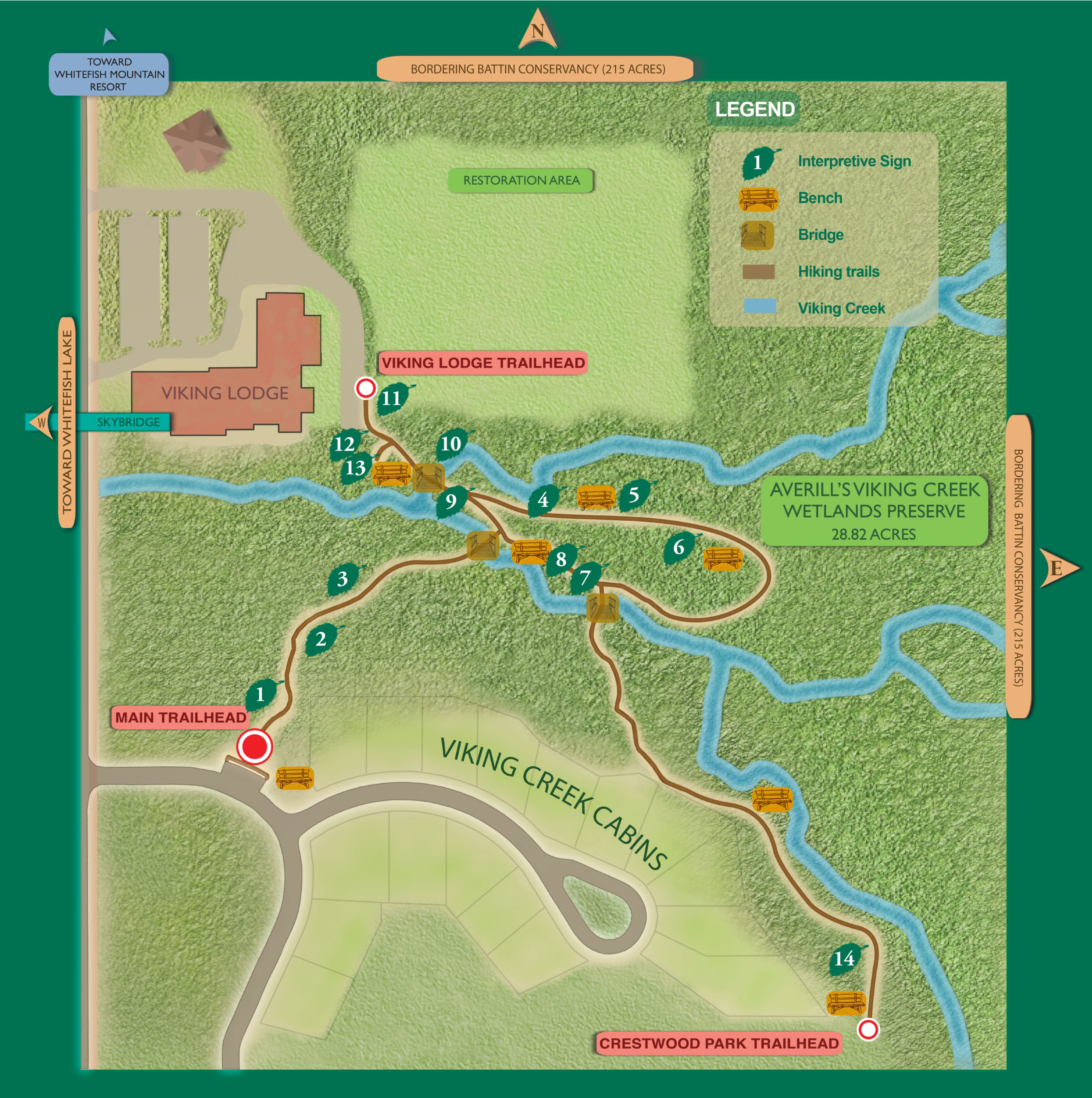
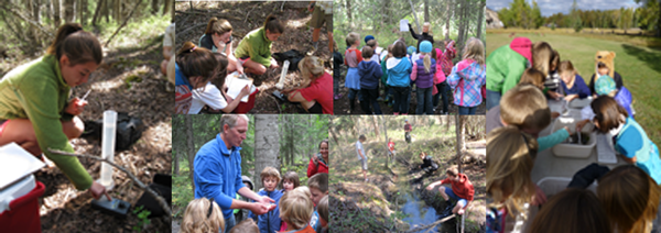
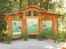
AN OUTDOOR CLASSROOM
In addition to hosting daily visitors, WLI also conducts research in the wetland through a partnership with the Whitefish High School Project FREEFLOW, hosts pre-K through 12 classroom visits, and provides senior learning programs at the trail. If you have a group of 10 or more and would like an interpretive tour led by WLI staff, please submit your request to cynthia@whitefishlake.org.

OutdoorEducationSiteseBooklet_Thumb
See pp. 36-37 of "A Teacher's Guide to Outdoor Education Sites and Programs in the Flathead Region" for educational information.

Septic Leachate Issue

Suspected septic leachate contamination in Whitefish Lake was reported in a study conducted by the Flathead Lake Biological Station in the mid-1980s. In 2012. the Whitefish Lake Institute (WLI) published a study that confirmed the presence of septic contaminants at several shoreline locations. The issue has existed for over 30 years, and as more septic systems age and fail, our clean drinking water is at risk.

In response to this ongoing threat to water quality, the Flathead Basin Commission (FBC) recently undertook an effort using a Geographic Information Systems (GIS) model to assess the density and age of Flathead County septic systems using the septic permit database. The model overlays physical risk factors such as depth to groundwater, soil suitability, slope, and distance to surface water.

Preliminary data from the FBC model shows roughly half of the permitted septic systems in the basin are older than 30 years. The model effort is currently working on estimate of even older non-permitted systems predating permit requirements that began in 1978. The model’s preliminary data corroborates the areas of concern on Whitefish Lake identified by the 2012 WLI report.

While water quality monitoring identifies the presence of septic leachate in waterbodies it does not identify the source of the contaminants. To solve this question, WLI and FBC are partnering with Cornell University to conduct a Synthetic DNA study in 2022. Synthetic DNA tracers are benign and have a unique signature that will allow the research team to pinpoint contamination sources in the upland area.

WLI is also participating on a team funded by a National Science Foundation Smart & Connected Communities grant to explore solutions to the septic issue. The group will host a septic leachate summit in May 2022 at the Flathead Lake Biological Station. Experts from across the nation will be invited to share information and develop solution strategies.

For more information:

Special Projects

SR_Gasoline-Constituent-Loading

Gasoline Constituent Loading and Motorized Watercraft Use Levels in Whitefish Lake
This 2005 study examined potential public health risk from motorized watercraft-caused gasoline constituent loading to shoreline areas used for recreation. WLI analyzed the levels of BTEX (benzene, ethylbenzene, toluene and xylene), agents known to cause myriad health problems from cancer and birth defects to nervous system, liver and kidney damage. Results found high levels of benzene at City Beach. WLI concluded that the main mechanism for the high levels of benzene was when a boat owner pulls their transom plug on the boat ramp, petroleum effluent enters the lake adjacent to the swimming area. WLI recommended the installation of a catchment system to collect the effluent. The Whitefish City Council approved financing for the project which was completed in 2013.

SR_Usage-of-Lake

Lake Usage Data
WLI developed and completed a survey detailing how the children of Whitefish use Whitefish Lake as a recreational resource. WLI surveyed children in grades 4, 8, and 11. With the support of Whitefish Public Schools, WLI achieved a 90% respondent rate of total enrollment. The survey found that 89% of respondents recreated in the lake that year. While fishing was not of great interest to the kids, 87% of them swam in the lake. Of the 87%, 29% claim to have swam twenty days or more. This social survey provided additional data to support the installation of the grate/catchment system at City Beach.

bigforkStormwaterProject
Bigfork Stormwater Project
WLI provided technical assistance to Flathead County and the Bigfork Storm Water Advisory Committee during the Bigfork Storm Water Project. WLI developed and implemented a Sample and Analysis Plan to collect water quality samples before and after storm water infrastructure and treatment devices were installed. WLI presented findings at the 2012 Montana Stormwater Conference, and the 2014 final project report is available here.
Tally_Lake_icon_100
Click to view the Tally Lake 3-D animation

Tally Lake
Tally Lake is the second deepest lake in Montana and regionally unique due to its morphometric (size and shape) attributes and chemical input (humic matter) from Star Meadows. Those factors, among others, lead to a severe depletion of dissolved oxygen at depth throughout the calendar year. WLI is the first to monitor Tally Lake from the surface to bottom (445 feet). In 2008, a preliminary study was funded by Montana Department of Environmental Quality (DEQ). From 2009 to 2013 work continued via a US Forest Service Resource Advisory Committee grants. From 2014 through the present, research on Tally Lake has been supported by WLI members.

Swan Lake
WLI conducted sampling on Swan Lake for the Montana Department of Environmental Quality in 2009. WLI also donated time to collect Hydrolab data and submitted that data to the Swan Ecosystem Center. Work continued from 2010 through 2013 via a combination of contracts with the Swan Lakers, Kootenai Lodge Estates and the Swan Ecosystem Center. WLI has provided a summary report and has presented information at two Swan Lakers Annual Meetings. WLI presented information at two Swan Lakers Annual Meetings, and the 2014 final project report is available here.

Blanchard Lake
Blanchard Lake is a warm water lake located about 2 miles south of Whitefish. The lake has relatively shallow depths, and no inflow or outflow of fresh water. Blanchard is broadly vegetated and supports several warm water fish and other aquatic species. WLI maintains two monitoring sites on the lake, where water quality monitoring parameters are collected using a Hydrolab DS5 Sonde. Water chemistry samples are also collected once annually as part of the NMLN program. Reporting on lake water quality was made to the Friends of Blanchard Lake, a group dedicated to protecting the water quality and natural resources of the lake and its surrounding area.

Community Participation

The Whitefish Lake Institute participates in numerous committees and commissions. Executive Director Mike Koopal serves as a member of the Flathead Basin Commission’s onsite wastewater treatment committee and served on the Whitefish Climate Action Plan Committee; Science & Education Director Cynthia Ingelfinger serves on the Flathead Basin Committee’s Education and Outreach Committee and on the Haskill Basin Watershed Group.

WLI is a member of the American Water Resources Association, the Association for the Sciences of Limnology and Oceanography, the North American Lake Management Society, and the Whitefish Chamber of Commerce.